Over the Top
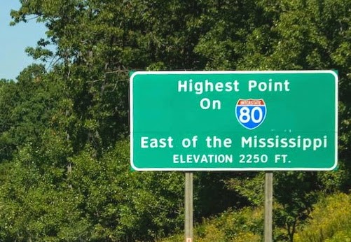
It is just east of exit 111 which means it is almost exactly 200 miles from New Jersey and, of course, 111 from Ohio.
 From there we kept moving downhill, until the one that heads down to Milesburg. It is, of course, a beautiful sight- in nice weather. Although I have to admit that I'm not sure the truckers would agree with me.
As we were heading back west on our way home, I became very aware of the climb- and the ups and downs of this highway. I wondered what the elevation profile looked like? So I did some Googling and found a path mapper and got the following three elevation profiles.
First is the whole of Interstate 80 from the Delaware River (left) to Ohio (right). It is quite a jumble of ups and downs. Having grown up in the Susquehanna Valley I noticed the relatively low elevation from about mile 65 to mile 90. On the eastern side of that is the North Branch of the Susquehanna and the western side, just before the climb is the West Branch.
I-80 elevation
East (NJ) to West (Ohio)
 |
| (Black lines - border of elevation below) |
I-80 elevation
Susquehanna River (West Branch) to DuBois
 |
| (Black lines - border of elevation below) |
I-80 elevation
Milesburg to just east of DuBois

Over the years much of this area has become more clearly forested. The highways that traverse that part of the state haven't taken away its wildness. You look ahead of you and you see the mountain climbing; look right or left and you see mountains and valleys and lots of trees. This is the western part of what was often called "The Endless Mountains." It is nowhere near as intimidating to my Ford-based travel as it would have been to horseback, wagon, or foot travel.
My final thought was how determined (stubborn?) or something those pioneers must have been.
Link to elevation mapper


No comments:
Post a Comment