Showing posts with label Susquehanna. Show all posts

Monday, May 25, 2015

Over the Top

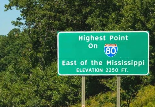
I grew up in the mountains of northern Pennsylvania, part of what is now often referred to by the tourism people as "The Pennsylvania Wilds." We recently made a road trip back across Pennsylvania and it's "iconic" northern route- I-80. I-80 does not intersect any major cities. In fact, it misses even some of the larger northern tier cities as well. But for me, in college, the eastern half of I-80 was my route to school. It has been over 30 years since we have been on the western part of the route. As we were heading east we passed the sign indicating the bit of travel trivia:


It is just east of exit 111 which means it is almost exactly 200 miles from New Jersey and, of course, 111 from Ohio.
From there we kept moving downhill, until the one that heads down to Milesburg. It is, of course, a beautiful sight- in nice weather. Although I have to admit that I'm not sure the truckers would agree with me.

As we were heading back west on our way home, I became very aware of the climb- and the ups and downs of this highway. I wondered what the elevation profile looked like? So I did some Googling and found a path mapper and got the following three elevation profiles.


First is the whole of Interstate 80 from the Delaware River (left) to Ohio (right). It is quite a jumble of ups and downs. Having grown up in the Susquehanna Valley I noticed the relatively low elevation from about mile 65 to mile 90. On the eastern side of that is the North Branch of the Susquehanna and the western  side, just before the climb is the West Branch.

I-80 elevation
East (NJ) to West (Ohio)
(Black lines - border of elevation below)

So I narrowed it down to the section in the mountains after crossing the Susquehanna. It is the section between the lines above, mile 1 on the left below. The first 30 miles climb up and along the southern edge of the mountains until entering a kind of valley south of Lock Haven, PA on to Milesburg, PA. Then the climb begins.

I-80 elevation
Susquehanna River (West Branch) to DuBois
(Black lines - border of elevation below)

The left line above is about Milesburg at the base of the Allegheny Front. The Allegheny Front is most famous for being the barrier to easy westward movement of the railroad across Pennsylvania. Then the Horseshoe Curve was designed and things changed. So, the 50 miles from Milesburg to just west of the high point is narrowed in on in the graph below.

I-80 elevation
Milesburg to just east of DuBois
As can be seen, there are really two major climbs. As we were climbing that one, it is where I became aware of how steep it really is. I thought of the pioneers who headed west from the relative ease of the coast and came upon this barrier. However they climbed, they had to keep climbing. Then, just when they thought they were at the top, there were only more mountains to climb.

Over the years much of this area has become more clearly forested. The highways that traverse that part of the state haven't taken away its wildness. You look ahead of you and you see the mountain climbing; look right or left and you see mountains and valleys and lots of trees. This is the western part of what was often called "The Endless Mountains." It is nowhere near as intimidating to my Ford-based travel as it would have been to horseback, wagon, or foot travel.

My final thought was how determined (stubborn?) or something those pioneers must have been.


Link to elevation mapper

Friday, September 20, 2013

Pondering Deep Roots

A passage from the remarkable book, The Telling Room by Michael Paterniti. Paterniti is responding to a transcendent moment in Spain, speaking of the life of the cheese maker he's been following. He reflects on the ancient life on the Spanish meseta where the cheese maker has always lived:

Divinity, Not Machines
I craved divinity. I was thinking about how Ambrosio [the cheese maker] had said he spoke to animals, as if they were close friends, confiding in them. ... I wanted to live in a realm where I could talk to animals, where all the generations of my family had once resided, where I might take daily strength in them, and where I'd live antlered by meaning and mysticism.
For me that resonated with my growing up in the West Branch Valley of north central Pennsylvania. Where Pine Creek joined the Susquehanna River I was rooted and grounded. A few years ago I started reflecting on that childhood homeland. That has been the early stirrings of writing that I hope to spend significant time working on when I move toward retirement in December. Paterniti's description spoke to me of my own roots in that land in Pennsylvania.

Creek at Ravensburg State ParkIt is what pulled me there over five years ago to ride the Pine Creek Rail Trail for my 60 miles for 60 years 60th birthday ride. It's what moves and inspires me when I look at that picture above this post on the banner of this blog. It is what stirs me when I think of the Bald Eagle Mountain on the southern boundary of the Valley or the Depression Era park I always called The Rocks. It may even be what so smoothly directed me to a church denomination that knew that area while still inhabited by the natives who called the Creek Tiadaghton.

It is the pull of water and trees;
Green hills and
Bald Eagles.

It is the mountains known as
Endless
But in the end were, for me,
Too limiting.
Lower Pine Creek PA
Yet they remain to define the
deepest places of my soul.

My soul, still,
decades after becoming a Midwesterner,
is solidly growing from the
rich geology, geography, river soil and
grandeur of that Valley.

Time will tell if I can tell that story. It is one of the dreams of what will become my Third Career starting in 2014. It will not be retirement; it will be a time of digging into that soil, pruning branches, examining the roots- and branches- that are fed by the memory of those mountains and waters.